SP8 Main Modifications
These Main Modifications are taken from the Inspectors document South_Tyneside_Local_Plan_-_Main_Mods_Appendix_-_FINAL.pdf.
We list them here in order to monitor how South Tyneside Council and any future developer will adhere without any deviation to the main modification.
However, throughout these modifications, the use of auxiliary modal verbs, could render the modification null, void and not in the sprit of what is required thus allowing the council and or the developer to do as they see fit.
|
Main Modification |
Happing? As Promised? |
|
To ensure the delivery of a cohesive and sustainable development, the Council will only approve a proposal that delivers the necessary local and strategic infrastructure in a timely and coordinated manner and in accordance with the requirements of this policy and other relevant policies within the Local Plan. |
|
|
Development shall: Provide a mix of house types, tenures and sizes, including a minimum of 25% affordable housing and self/custom build housing opportunities, in accordance with Policies 19 and 20. |
|
|
Provide a well located and connected local centre for social and community infrastructure of a scale proportionate to the nature and size of the development and to address local needs. The local centre shall include: |
|
|
Through a vision-led approach to transport planning, embed sustainable and active travel options to reduce the dominance of car traffic and improve permeability by: |
|
|
Deliver vehicular access roads to the site from: |
|
|
Protect and strengthen the remaining Green Belt by: |
|
|
Be landscape led and deliver a well-connected network of good quality, publicly accessible green and blue infrastructure provision, including walking and cycling infrastructure, recreational open space and play provision both within the development site boundary and within the remaining Green Belt, where compatible with the purposes of the Green Belt. |
|
|
Avoid, wherever possible, an adverse impact and, where necessary, mitigate the impact, of the development on biodiversity, wildlife corridors and ecological designations and, where possible, enhance these interests through ecological mitigation, compensation and biodiversity net gain delivery in accordance with Local Plan Policies 33, 34, 35 and 36. |
|
|
Embed sustainable and high-quality design principles throughout the site. Development proposals for this site should adhere to Policy 47 and the following key design principles, and as set out in Inset Map 10: |
|
|
Strategic Highways Improvements and enhancements |
|
|
Implementation |
|
|
Supporting text: The boundary for the allocation has been informed by the South Tyneside Green Belt Study (2023), which is an independent assessment of the ‘harm’ of releasing land from the Green Belt to accommodate potential development needs. It concludes the least harm to the Green Belt is at the northern edge of the land parcel adjacent to the urban area. Development proposals shall be in accordance with a masterplan approved by the Council, and which shall accompany any initial application for planning permission and shall be informed by the criteria set out in Policy SP8 and the indicative layout as identified in Inset Map 10. The masterplan should set out the intended overall design and layout of the development and include a phasing and implementation plan. In order to ensure high quality design, the masterplan should also be accompanied by a Design Code. Inset Map 10 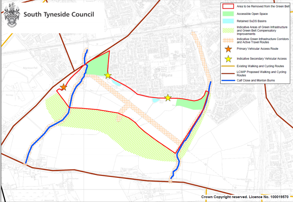 Housing provision A new Local Centre shall be provided to serve both new and existing communities in the area through the location provision of community services, local scale retail, food and drink, primary school and opportunities for a primary health care provision. The primary health care provision shall be agreed with the local Integrated Care Board (ICB) (or any successor body) and delivered to a specification agreed with the ICB and either delivered directly by the developer or through payment of a financial contribution sufficient to ensure its delivery. The Local Centre is to be located to coincide with sustainable transport routes, accessibility to the existing Fellgate estate and the green infrastructure network. An assessment of the likely education requirements for this site by the Council has indicated that the site should make provision for land to accommodate a new primary school. The school will be delivered to a specification agreed with the local authority and either delivered directly by the developer or through payment of a financial contribution sufficient to ensure its delivery. |
|
|
Active Travel and Transport Enabling and delivering sustainable travel is a key objective in the delivery of this site and it is essential that active travel options are embedded with the development from the outset to accord with the vision-led approach to transport set out in Transport Circular 01/2022: ‘Strategic road network and the delivery of sustainable development’. The Sustainability Accessibility Review (2021) states that, given the site is currently greenfield, pedestrian connectivity is currently poor. There will need to be a step-change in connectivity for pedestrians and cyclists. Development proposals will demonstrate how the ability to travel by foot or cycle will be actively encouraged by the delivery of well designed, safe, and convenient access to the site and also through the site. Both existing and proposed walking and cycling routes in the Local Cycling and Walking Infrastructure Plan 2021 – 2036 must demonstrably be taken into account. In addition to creating new connections throughout the site, it is also important the Growth Area is well connected to the existing Fellgate estate, its infrastructure and public transport connections. Fellgate Metro station is a key asset in terms of supporting and encouraging public transport use for the Fellgate Sustainable Growth Area. The Sustainability Accessibility Review (2021) states that the most direct walking route from the development to Fellgate Metro station would be to the north of the site travelling via Durham Drive or winding through the estate via a series of footways and footpaths. The distance from the north of the site to the Metro Station is approximately 800m. Durham Drive provides a surfaced link with street lighting, a 20mph speed restriction, making it suitable for both cyclists and pedestrians. Upgrading it to cycle infrastructure design LTN 1/20 standard will enhance its suitability and accessibility to the Metro Station. Where possible, new sustainable transport routes should not only connect the new site to the existing residential area, but also to the wider area and where possible support connectivity into the wider area and neighbouring authorities. The Sustainable Accessibility Review (2021) recommended that western road access to the site is achieved from the A194 / Mill Lane junction and northern road access from Durham Drive. Details of all necessary on and off-site highway works and improvements, together with a timetable for their implementation, shall be agreed with the Council as part of the comprehensive masterplan accompanying the initial planning application. |
|
|
Green Belt Compensatory Improvements and Green – Blue Infrastructure. The Growth Area shall provide a new, well-defined and robust boundary will bolster the permanence of the remaining Green Belt and provide a more robust barrier to future encroachment. Green and Blue Infrastructure should be provided throughout the Fellgate Sustainable Growth Area and complement enhancements through the remaining Green Belt identified as compensatory Green Belt improvements. Compensatory improvements to offset the loss of land from the Green Belt may include woodland planting, landscape and visual enhancements, improvements to biodiversity. Potential mitigation and enhancement measures for the Green Belt allocations are outlined in the South Tyneside Green Belt Study (2023) and South Tyneside Green and Blue Infrastructure Strategy (2023). Green-Blue infrastructure provision will be expected to include new or enhanced walking or cycling routes, children’s play facilities and improved access to new, enhanced or existing recreational and playing field provision. Open space provision and playing pitch requirements should be provided in accordance with the Council’s most recent Open Space Study and Playing Pitch Study. |
|
|
Natural Environment |
|
|
Sustainable Urban Drainage – SuDS Appropriately designed SuDs should be incorporated into the development in accordance with the 4 pillars of SuDs design in order to protect water quality, control water quantity and improve the amenity and biodiversity value of the area prior to discharge into the nearby watercourses. The North East Lead Local Flood Authorities’ SuDS standards should be followed in the approach to SuDS design within the development. The density of development across the site should respond to wider site characteristics and constraints. The most appropriate areas for higher densities (50+ dph) will be close to local services; public transport stops and existing development. However, building height and form should consider impacts on existing residential properties. It is envisioned that most of the site would be suitable for medium density development (30 -50 dph), with lower density housing (20-30 dph) located on the Green Belt edge to help the built form blend into the adjacent landscape. Lower density areas can be landscape led with areas of planting and large green front gardens to soften the edge of the development. |
|
|
Suitable storey-heights in the Fellgate Sustainable Growth Area include: • Residential Dwellings: 2, 2.5 and 3 storey Areas of open space identified on Inset Map 10, should provide for accessible open space and landscaping opportunities. These areas should be retained and enhanced as part of the development. The site should provide connections through to Green Belt land so that residents can access natural green space. There is also an opportunity to provide facilities such as playing parks in the Green Belt adjacent to the site. Across the centre of the site is a row of pylons. This existing infrastructure should be considered as part of the masterplanning process including options for potential diversion or undergrounding. Such options are strongly supported and would add to the overall quality of the development as part of creating a well-designed place. In a scenario that the pylons were retained, masterplanning and design codes would need to take into consideration any necessary easements to each side of the pylons and appropriate land uses in the vicinity of this infrastructure. |
|
|
Strategic Road Network – White Mare Pool Junction |
|